Services
Clear, practical drone services designed to support inspections, planning and visual communication.
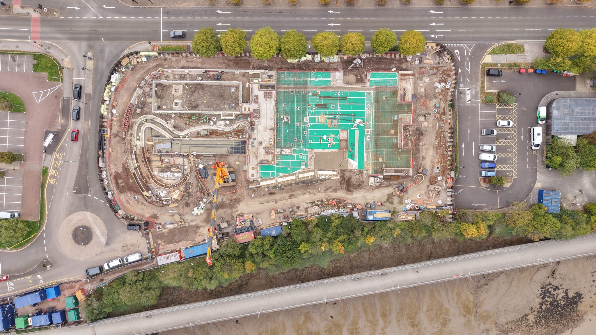
Inspections
Drone-based inspections designed to capture clear, usable visual information in areas that are difficult, time-consuming, or impractical to access by traditional means.
The focus is on factual, high-quality visual evidence that supports maintenance planning, condition assessment, and decision-making – either directly by the client or alongside other professionals.
Typical inspection applications
- Commercial and industrial roof inspections
- Building façades, gutters, chimneys and external features
- Plant, structures and exposed steelwork
- Yards, hardstanding, drainage runs and perimeter fencing
- Telecoms infrastructure and elevated assets
- Internal spaces such as warehouses, large halls, and roof voids
- Confined or restricted areas where drone use is appropriate and safe
Internal & restricted environments
Where conditions allow, drone inspections can be carried out in large internal spaces, roof voids or ceiling spaces with limited access, low-light environments using onboard lighting, and tight or constrained areas using guarded aircraft.
Each environment is assessed individually to ensure suitability, safety, and practicality before any work is undertaken.
How the inspection is carried out
- Site context and requirements are discussed in advance
- Flight planning and risk considerations are addressed before arrival
- Equipment is selected based on the environment and task
- Inspections are carried out efficiently, often with minimal site time
- Outputs are processed and delivered in a clear, usable format
Work can be coordinated around active sites, out-of-hours access, or site escorts where required.
Turnaround times
Delivery times depend on the scope of work and required outputs.
Photography and video can often be delivered from the next working day. Larger datasets or 3D models are typically delivered within 2–3 days, depending on scale and complexity.
Faster turnaround may be possible where required and agreed in advance.
Suitability & professional boundaries
This service provides visual data and documentation, not professional interpretation.
I am not a surveyor or engineer, but the outputs supplied can support informed decisions and are well suited for use alongside appropriately qualified professionals when required.
What you get
High-resolution photographs (edited or raw)
Video clips (edited or unedited)
Clearly labelled issue-capture images
Annotated imagery with mark-ups or call-outs
Before-and-after comparisons where applicable
A concise written summary outlining what was inspected
Where conditions allow, 3D models of structures or plant can also be produced to support further review or planning.
Mapping & Models
Mapping and modelling services designed to create clear, visual representations of sites, assets and layouts for planning, tracking and communication.
The emphasis is on producing usable visual outputs that help clients understand space, change and progress — rather than providing survey-grade data or formal measurements.
Typical applications
- 2D orthomosaic site maps
- Asset layout and space planning
- Visual planning and layout overlays
- Progress tracking over time
- Before-and-after comparisons
- Visual records for reports or stakeholders
Environments and site types
Mapping and modelling work is commonly carried out across a range of environments, including construction sites, storage yards and compounds, industrial estates, quarries, brownfield land, and active operational sites.
Each site is assessed individually to ensure the approach, outputs and level of detail are appropriate for the environment and intended use.
Mapping outputs and models
- Scale-accurate 2D orthomosaic maps
- Annotated maps and layout visuals
- 3D mesh models for visual reference
- Fly-throughs generated from 3D models
- Still images extracted from models
- Elevation models (DSM / DTM) for visual context
- Relative volume or cut-and-fill estimates derived from the model
How this data is used
These outputs are typically used for visual planning, space assessment, progress communication and internal decision-making.
Where survey-grade accuracy or formal validation is required, mapping outputs can be provided to or produced alongside appropriately qualified professionals.
Turnaround and repeat capture
Turnaround times depend on site size, complexity and required outputs.
Smaller sites are typically delivered within 1–2 days, with larger or more complex sites taking longer depending on scope. Ongoing or repeat capture can be arranged where progress tracking over time is required.
Suitability and limitations
Mapping and modelling outputs are produced for visual support and planning purposes.
They are not a topographic survey, are not survey-grade, and are not intended for legal boundary definition or engineering calculations unless produced and validated alongside appropriately qualified professionals.
What you get
- Annotated 2D orthomosaic maps
- Visual layout and planning outputs
- 3D mesh models and fly-throughs
- Still imagery extracted from models
- Before-and-after visual comparisons
- Clear, organised deliverables ready for review or sharing
Photo & Video
Aerial photo and video services focused on capturing clear, purposeful visuals rather than purely cinematic or promotional content.
The emphasis is on showing sites, assets and environments as they are — supporting communication, documentation, and marketing where appropriate, without unnecessary gloss.
Typical applications
- Commercial and industrial properties
- Operational and active sites
- Facilities, yards and compounds
- Progress or milestone documentation
- Marketing imagery for businesses
- Community and charity projects
Environments and permissions
Photo and video work can be carried out across a wide range of environments, provided operations are legally viable and appropriate for drone use.
Where additional permissions or coordination are required — such as in controlled or sensitive areas — this is identified in advance, with timelines adjusted accordingly or alternative approaches discussed where necessary.
Style and approach
The visual style is driven by the purpose of the work rather than trends.
In some cases this may be clean and factual, focused on documentation. In others, a more polished or cinematic approach may be appropriate. The level of editing and presentation is agreed upfront, ensuring the final outputs suit how they will be used.
What you receive
- Edited still photographs
- Edited video clips
- Vertical video for social use
- Short highlight reels
- Longer walkthroughs or fly-throughs
- Raw imagery or footage on request
Professional boundaries
This service focuses on providing aerial photo and video capture.
It is not a replacement for a full marketing agency, does not include lifestyle or influencer-style content, and does not involve FPV stunt flying or filming over crowds. All work is planned and carried out with safety, separation distances and legal requirements as the priority.
What you get
- Purpose-led aerial photographs
- Clear, usable video outputs
- Flexible formats for documentation or marketing
- Deliverables prepared for easy sharing or use
- A straightforward, professional workflow
Not sure which service fits?
If you’re unsure what would be most useful for your site or project, get in touch and I’ll help you work it out.